
JERUSALEM – HIEROSOLYMA BY BRAUN & HOGENBERG 1575

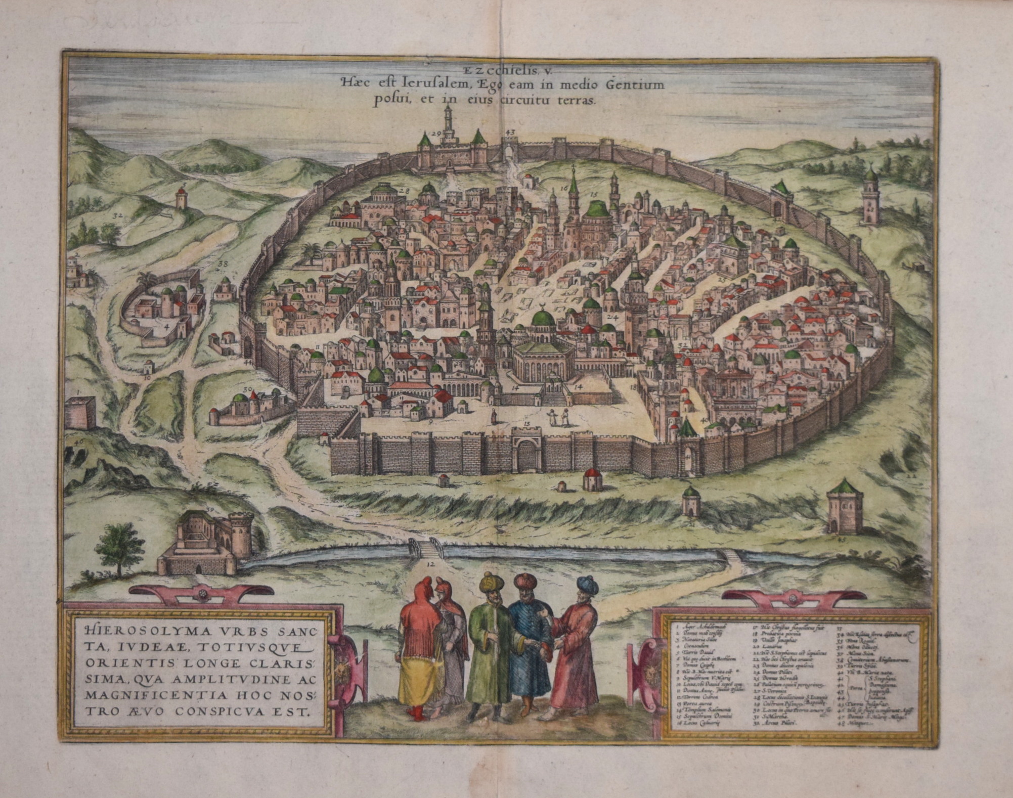
HIEROSOLYMA VRBS SANCTA....
A highly attractive copper line engraving on paper, produced to accompany Braun & Hogenberg's "Civitates Orbis Terrarum", and first published in Cologne 1575.
Measures approx. 330 x 420 mm. Excellent condition.
Attractive Hand Colour.
A guaranteed genuine antique map.
TRANSLATION OF CAPTION: This is Jerusalem; I have set it amid the nations and countries around her."
CARTOUCHE: Jerusalem, the holy city, the most famous of Judea and the entire East, whose size and splendour marvel the imagination.
COMMENTARY BY BRAUN: " The particular holiness and significance of Jerusalem stem from the divine prophecies and miracles God created in all his supreme power. Especially, however, because Christ, the Son of God, as he walked the earth, not only lived and learned mostly in this city but also accomplished many wondrous deeds: his prayers, his suffering, death, burial, resurrection, Ascension, spreading the Holy Spirit and dispatching his disciples out into the world."
Whereas the first depiction of Jerusalem shows the city as described in the Old Testament, this second plate features a contemporary bird's-eye view from the otherworldly height of Kidron Valley as well as the most important sites and structures having to do with the life of Jesus and his disciples: among others, the birthplace of Mary, the Calvary and the Church of the Holy Sepulchre, the residences of Pontius Pilate and Herod, the place before the city gates were Stephen was stoned as well as where John the Baptist was beheaded. In the centre of the image, the Temple of Solomon is depicted - since the late 7th century, the location of the Islamic Dome of the Rock bears a crescent on its dome.
FRANS HOGENBERG
Frans Hogenberg (1535–1590) was a Flemish and German painter, engraver, and mapmaker. Hogenberg was born in Mechelen in Flanders as the son of Nicolaas Hogenberg. In 1568, he was banned from Antwerp by the Duke of Alva because he was a protestant and had printed engravings sympathizing with the Beeldenstorm. He traveled to London, where he stayed a few years before emigrating to Cologne. He is known for portraits and topographical views as well as historical allegories. He also produced scenes of contemporary historical events.
Hogenberg died in Cologne.
GEORG BRAUN
Georg Braun (also Brunus, Bruin; 1541 – 10 March 1622) was a German topo-geographer. From 1572 to 1617, he edited the Civitates orbis terrarum, which contains 546 prospects, bird's-eye views and maps of cities from all around the world. He was the principal editor of the work, he acquired the tables, hired the artists, and wrote the texts. He died as an octogenarian in 1622, as the only survivor of the original team to witness the publication of volume VI in 1617.
Braun was born and died in Cologne. His principal profession was as a Catholic cleric. He spent thirty-seven years as canon and dean at the church, St. Maria ad Gradus, in Cologne. His six-volume work was inspired by Sebastian Münster's Cosmographia. In form and layout it resembles the 1570 Theatrum orbis terrarum by Abraham Ortelius, as Ortelius was interested in a complementary companion for the Theatrum.
The Braun publication set new standards in cartography for over 100 years. Frans Hogenberg (1535–1590, from Mechelen) created the tables for volumes I through IV, and Simon van den Neuwel created those for volumes V and VI. Other contributors were Joris Hoefnagel, Jacob Hoefnagel, cartographer Daniel Freese, and Heinrich Rantzau. Works by Jacob van Deventer, Sebastian Münster, and Johannes Stumpf were also used. Primarily European cities are depicted in the publication; however, Cairo Casablanca and Mexico City as well as Cuzco on one sheet are also included in volume I, whereas Tunis is featured in volume II.f town plans, issued in six volumes between 1572 & 1617. The plans were collected from different sources, resulting in a wide range of artistic styles, and were engraved by Franz Hogenberg, with a text edited by Georg Braun. Designed as a sister publication to the Ortelius atlas, the 'Theatrum Orbis Terrarum', it included many of the earliest extant plans of many places, including London.
£1,750.00
Related products
-

A NEW MAP OF THE EMPIRE OF PERSIA. LAURIE & WHITTLE 1810
£480.00 Add to cart -

ARABIA BY JOHN TALLIS 1850
£240.00 Add to cart -

IRAN. PERSIA BY EDWARD WELLER 1863.
£45.00 Add to cart

Philip Sharpe antique maps
info@philipsharpegallery.com
CALL
#44 (0) 743 229 0515